NevadaToday
Finding faults How the burgeoning Walker Lane may split the American West
Finding faults
California won’t fall into the ocean, but it could get nudged hundreds of miles offshore, making Nevada the new coastline of the continent, scientists at the Nevada Bureau of Mines and Geology at the University of Nevada, Reno hypothesize. They have combined decades of data and the latest technology to study the Walker Lane, an approximately 1000-kilometer-long (625 miles) corridor riddled with hundreds of earthquake faults.
Several researchers at the University are part of a group of scientists who are studying the massive system of relatively discontinuous faults that runs through western Nevada. It is known as the Walker Lane and in about 7-8 million years or so could become the new tectonic boundary between the North American and Pacific plates. The group at the University is relatively rare, as it includes expertise that analyzes fault zones at three different time scales from tens of millions of years (structural geology/tectonics) to the past approximately two million years (paleoseismology) to the present (geodesy). This combination of expertise is needed to understand the evolution of something potentially as grand as the Walker Lane. In essence, the University team combines the most modern fieldwork techniques with the latest technologies such as satellites, LIDAR and computer simulations.
The notion that a major strike-slip fault system is developing just east of the Sierra Nevada is not new, but recent technological advances have made it easier to locate and map the numerous earthquake faults in the region giving more evidence to the speculative yet plausible geological idea. And the idea has received some national media attention.
The recent 7.1 magnitude earthquake in Ridgecrest, California, which sits east of the Sierra Nevada and lies within the southern part of the Walker Lane, is a reminder that the inland fault system, the Walker Lane-eastern California shear zone, is a little known, but fundamental part of the plate boundary between the Pacific and North America tectonic plates.
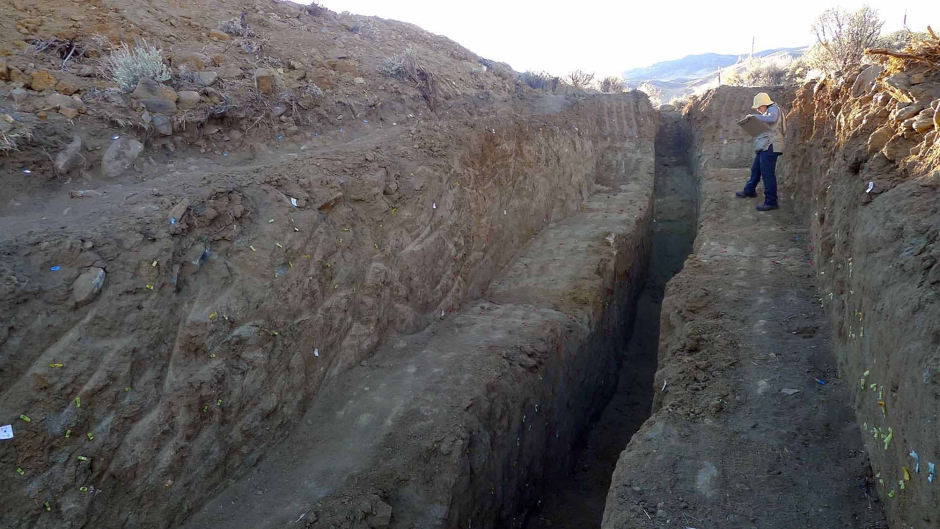
Paleoseismology: looking back
The 2019 Ridgecrest quake was the largest earthquake in California in the past 20 years. Rich Koehler, a paleoseismologist in the College of Science’s Nevada Bureau of Mines and Geology was there for the shaking.

“My specialty is paleoseismology, so I map evidence of faulting on the ground, including the location and age of soil deposits that are offset to figure out how much earthquake movement has occurred in the past,” he said. “We were in the area to study and map the 6.4 magnitude earthquake that happened there on July 4. There were a lot of geologists, seismologists and engineers and people with other specialties in the area doing the same as we were. They were part of a GEER team (The Geotechnical Extreme Events Reconnaissance Association). We were invited to conduct additional surveys, so we decided to stay one more night.”
GEER members donate their time, talent and resources to collect time-sensitive field observations of the effects of extreme events, such as the Ridgecrest earthquake. They reported that more than 1,200 ground motions were recorded from the Ridgecrest foreshock and mainshock alone, with many additional aftershock records. Koehler and a graduate student, Ian Pierce in the Nevada Seismological Laboratory, joined the effort and went to the first meeting of the group the evening of July 5.
“That night we were at dinner when the 7.1 hit just after 8 p.m.,” Koehler said. “Our plans changed.”
Koehler connected with graduate students and other scientists from Arizona State University and other universities who were also on scene.
“I took a small team with me. Not many teams were looking at the southern end of the fault, so we focused there,” he said. “We mapped the entire southern part of the rupture looking for surface fractures and getting pictures to make aerial photo mosaics of the southern end, including some drone imagery.”
The team contributed their findings to the multi-agency effort, using their part of the study of the rupture offsets – the slip distribution of offsets and how big they were (how much the surface moves laterally and vertically).
“The offsets of the entire fault were impressive, going from one meter in the north to five meters in the middle and then to one meter in the southern end,” Koehler said. “We followed the fault to the very end, where the rupture tapers down to decimeters.”
The Ridgecrest earthquake was north of the Garlock fault, where the San Andreas Fault takes a turn to the west as it heads south.
“There were no faults mapped previously along the Ridgecrest rupture, so sometimes we get surprises like this,” he said. “So now we are mapping some.”
The 6.4 magnitude earthquake, now referenced as a foreshock to the 7.1, was what the geologists call a left-lateral fault. It was intersected, at almost 90 degrees, by the right-lateral fault that ruptured in the 7.1 earthquake, cutting it in half. The 6.4 quake surface rupture was 15 kilometers long (nearly 10 miles). The 7.1 quake surface rupture was 50 kilometers long (about 30 miles). Both earthquakes initiated at 15 kilometers (nearly 10 miles) beneath the surface.
“There are many active faults in the Walker Lane,” Koehler said. “Where we have lots of data – both geodetic and on the ground – we find it matches well. If we have lots of data, we can more accurately define the locations of faults on the ground.”
Koehler and his team also wrote a scientific paper that was published in the Science Direct publication Geomorphology about fault activity in the North Valleys area to the northeast of Reno. The paper focuses on seven main fault zones that define the North Valleys, including from west to east, the Last Chance, Petersen Mountain, Lemmon Valley, Fred's Mountain, Hungry Valley, Spanish Springs Valley and Spanish Springs Peak fault zones.

Comparison of the geographic distribution of active faults and basins encompassing the North Valleys shows that they are less developed than basins farther to the south and have had less time to develop into linked faults, partially due to the geologically recent northwest propagation of the northern Walker Lane into the region in the past 3 to 5 million years.
Using LIDAR-derived hillshade images, aerial photographs, satellite imagery and field reconnaissance, the study finds that the faults of the North Valleys are capable seismic sources. The faults in the North Valleys region act to transfer slip from the Sierra Nevada range front to the northeastern Walker Lane.
“The numerous faults are capable of producing earthquakes at any time,” Koehler said.
Odyssey for geodesy
The Walker Lane is not a continuous fault like the San Andreas, but its beginning and end are apparent to seismologists, geologists and geodesists.
In the 1990s geodesists saw an opportunity with GPS (global positioning system) and began strategically installing fixed GPS monitoring stations in relation to known fault systems. Geodesy is the study of the Earth's shape and motion, and using this technology allowed them to track crustal movement over time by picking up signals from the GPS network. Essentially, the GPS stations communicate with satellites to record fine-scale (millimeters) movements of the Earth’s crust.
In the Walker Lane and surrounding areas, there are over 400 monitoring stations, known as benchmarks, but hundreds more around the globe allow the geodesists to track movement most anywhere. The vast amounts of data gleaned from the satellites are processed in the Nevada Geodetic Lab’s servers within the Nevada Bureau of Mines and Geology and provided online so that scientists around the world can use the data for their studies.
For ease of study, the 100-kilometer-wide (65 miles) Walker Lane is referenced in three sections: southern, central and northern (Reno is in the northern section). The southern part, where the Ridgecrest earthquakes occurred, is sometimes called the eastern California shear zone.
While the San Andreas fault system moves 35 millimeters a year, the southern Walker Lane moves about 10 millimeters a year, and near the latitude of the Reno area the northern Walker Lane moves about 5 to 7 millimeters a year. In all, about 20-25 percent of the 50 millimeters per year movement of the Pacific-North American plate boundary happens east of the Sierra Nevada in the Walker Lane and Basin and Range Province, which stretches from the eastern Sierra to Texas, Oregon down to central Mexico.

These precise measurements are made possible through the use of geodesy, which can record millimeter-scale elevation and lateral changes in the landscape as the Earth’s crust crumples, stretches and grinds from tectonic plate movement.
The strain accumulation of the fault systems and the resulting earthquakes are tracked with the MAGNET GPS Network at the University of Nevada, Reno – and using other similar systems operated by other agencies.
Using GPS observations, scientists measure the active and ongoing current deformation of the crust that is the prelude to earthquakes on faults that release a portion of the accumulated strain. Combined with more GPS stations and more LIDAR data, detecting these motions in the Earth is becoming more precise and pervasive. Scientists can see the imperceptible-to-the-eye, yet continual, motion of the terrain in addition to earthquakes.
In one of their studies, published in the scientific journal Earth and Planetary Science Letter in 2016, the Nevada Geodetic Lab focused on active deformation in the central Walker Lane, which they defined as the set of normal and strike-slip faults that extend from about Mono Lake in the south to just east of Carson City in the north to the east of the Sierra Nevada.
In this study there is a significant improvement in resolution over previously published central Walker Lane GPS velocities. The authors, Jayne Bormann, Bill Hammond, Corné Kreemer and Geoffrey Blewitt – all in the Nevada Geodetic Laboratory in the Bureau of Mines and Geology at the time of the research – combined spatially dense semicontinuous GPS observations from their MAGNET system with continuous GPS observations from the National Science Foundations Network of the Americas to show that GPS velocities in the northwest direction increase smoothly by 8 millimeters per year across the central Walker Lane.
The University of Nevada, Reno has the largest GPS data-processing center in the world, which processes information from about 18,000 stations around the globe continuously, 24/7. The Nevada Geodetic Laboratory has a global catalog of publicly available GPS data going back to 1996 and reprocesses all 15-million data files as new data streams come in – every 30 seconds – solving for tens of thousands of parameters at once. It enables real-time positioning for any users. People around the world use it extensively for research, such as modeling earthquakes and volcanoes. The resulting information is freely available to anyone on the internet.
LIDAR
Another new tool used by the scientists is airborne Light Detection and Ranging technology, known as lidar. The Nevada Bureau of Mines and Geology received funding for a program in 2016, data from the study became available in July 2018.

“We can use LIDAR to discover previously unknown earthquake faults,” Faulds said. “The high resolution data are collected by bouncing light pulses off the surface of the earth. Faults that are hidden by vegetation stand out and are easily identified, which helps us decide where to study, or dig trenches, to learn more about the fault.”
Spearheaded by Nevada Bureau of Mines and Geology faculty member and Geologic Mapping Specialist Seth Dee, a Bureau lidar project for the Reno area received initial funding through the USGS and the Office of Research & Innovation at the University of Nevada, Reno.
Dee said the new LIDAR data acquisition for the area “is the equivalent of getting a much better lens on a telescope. The best topography widely available 20 years ago was from contours every 40 feet (13 meters) on a topographic map. With LIDAR we get a grid of data with elevation measurements spaced at least every three feet (1 meter), accurate to four inches (10 centimeters) vertically. We can now quickly map sub-meter geologic features, in addition to countless applications in other disciplines.”

Just one of the many geologic features found so far in the study includes the discovery of more than two dozen previously unknown faults and a better understanding of many known faults.
“These data can help us focus in on where to conduct our geologic work,” Faulds said. “We see there is a fault scarp at a certain location; we now know we need to go there to learn more. This, in turn, will help us put together the puzzle of the Walker Lane and better understand how its evolution is relevant to assessing earthquake hazards in the region. Utilizing the most modern technology is really crucial to unraveling something as complex and intriguing as the Walker Lane.”
Tectonic influences
“Ridgecrest is a notice that the Walker Lane is active, though maybe not as active as the San Andreas Fault, and has had a number of major earthquakes over time," Jim Faulds, director of the Nevada Bureau of Mines and Geology at the University of Nevada, Reno, said. “For example, in the Lone Pine, California area there was a 7.8 magnitude earthquake in Owens Valley, with more offset than Ridgecrest's nearly 5 meters (15 feet) of offset – it was smack in the middle of the Walker Lane.”
Faulds and Chris Henry (also with the Nevada Bureau of Mines and Geology) wrote a paper titled “Tectonic influences on the spatial and temporal evolution of the Walker Lane” in 2008. The paper synthesized decades of work and copious amounts of data collected by many groups at multiple institutions (including the University) to track the evolution of the Walker Lane through time and relate it to plate tectonic events particularly to the development of the San Andreas Fault. They found that the Walker Lane was intimately tied to plate boundary events from its inception about 13 million years ago in southern Nevada near Las Vegas to its present configuration, which began to develop along the east side of the Sierra Nevada about 10 million years ago, coincidental with a shift of the southern part of the San Andreas into the Gulf of California.
But it’s the combination of three science disciplines that illustrates the prominence of the Walker Lane – paleoseismology, geodesy and Faulds’ specialty of structural geology/tectonics. All three perspectives are crucial in analyzing something like the Walker Lane, because they provide three different timeframes with which to evaluate the evolution of the Walker Lane – from what’s happening now, to the past million years or so, and to the long-term (back-tracking tens of millions of years). We have all three disciplines in the College of Science at the University of Nevada, Reno.
Using the long-term evolution of both the San Andreas and Walker Lane, Faulds and Henry’s scientific paper predicts that the northern part of the San Andreas will shift inland to the Walker Lane in about 7 to 8 million years. The Gulf of California will expand to the north as this occurs, turning California into a peninsula hundreds of miles long along the coast of the new plate boundary. Reno would eventually lie on or near the new coastline of the elongated Gulf of California; which would also be the boundary between the two tectonic plates. It would take 7-8 million years for the plate boundary to shift to the Walker Lane, and this would definitely not take place in one large seismic event.
“Thirty million years ago, the Sierra looked like the Andes; then the plate boundary started changing and the new movement induced collapse of very high mountains and development of the Basin and Range,” Faulds said.

"The Walker Lane is in the beginning stages of development, similar to the San Andreas 20-30 million years ago," Faulds said. "Unlike the 30 million year old San Andreas fault that extends 1,100 kilometers (700 miles) as a continuous fault, the more youthful – 10 million years old in the south and less than a few million years old in the north – Walker Lane is composed of relatively discontinuous, only locally interconnected, strike-slip faults that are generally less than 100 miles long (160 kilometers).
“Most faults in the Walker Lane have the same relative motion as the San Andreas Fault. The western side of the Walker Lane is moving northwest one centimeter per year (about a half inch). Although the San Andreas is currently moving four times as fast as the Walker Lane, the long term evolution of the plate boundary suggests that the Walker Lane will likely speed up through time."
While the plates experience continuous movement along the plate boundary, the individual faults are mostly locked up because of friction. They slip relatively infrequently, and that is when there’s an earthquake.
Where is it, exactly?
The Walker Lane starts in the Mojave Desert in southern California and extends to the east of the Sierra Nevada, north through western Nevada in the Reno area and then into northeast California.
The San Andreas and the Walker Lane intersect north of Baja California and south of the Sierra Nevada at what is known as the Big Bend, where the San Andreas makes its turn to the west before heading in its classic northwestward direction.
From the south, the Walker Lane runs into Bishop and Death Valley, California.
“Death Valley is fully within the Walker Lane,” Faulds said. “The Sierra crest is moving laterally to the right and pulling away from areas to the east. The crust is stretching apart in this region – so it’s no surprise Death Valley and Mt. Whitney, respectively the lowest and highest points in North America, are in the same area.”
From there, the system then heads north into Nevada near Hawthorne, then through the Reno area, northwest to Susanville and then into northeast California near the town of Alturas. In Bishop, California, the Walker Lane started forming around 10 million years ago. It’s about four million to five millions years old in the Reno area and one million to two million years, or less, in the northern section in northeast California.

“There are a lot of faults in Reno – most of the motion is vertical, but GPS tells us there is some right lateral motion – the main Walker Lane faults are to the east of us in the Fallon/Fernley/Pyramid Lake area," Faulds said. "It's interesting to note that the bottom of Tahoe is lower than Reno in elevation – the Tahoe West Shore faults are active and cut glacial moraines that are only about 12,000 years old. These West Shore faults curve northeast into the Walker Lane system between Lake Tahoe and Susanville.”
The northern Walker Lane is the youngest part of the system, very young in geologic terms.
"There are conspicuous faults all the way north to Honey Lake, then the big faults end where the Walker Lane runs into the Modoc Plateau with lots and lots of little faults," he said. "The faults are quite disorganized. Eventually, the Walker Lane would extend through northeast California, to southwest Oregon, and then go off the coast in central Oregon. In the very long term the Walker Lane could connect northward with the Queen Charlotte fault near the coast of British Columbia in Canada, cleaving off a large sliver of land encompassing most of California and parts of Nevada, Oregon and maybe Washington and sending them north toward Alaska."
This progression in the Walker Lane from south to north is reminiscent of the northward growth of the San Andreas Fault over the past 30 million years.
“The Walker Lane aspires to be the San Andreas,” Faulds said. “If we look at the evolution of the San Andreas through time as a guide, then the Walker Lane is poised to be the plate boundary in about seven to eight million years from now.
“We can understand future geology by looking to the past, and this is one of the best natural laboratories on Earth to study major fault development – how major fault zones and new plate boundaries are formed or born and how they evolve over time.”


