
At a Glance
- Hurricane Laura roared ashore in southwest Louisiana as a strong Category 4.
- Laura pummeled western Louisiana and east Texas with surge flooding and high winds.
- Surge flooding up to 19 feet was documented in Cameron Parish, Louisiana.
- Wind gusts of 100 to 135 mph were recorded in southwestern Louisiana, including Lake Charles.
- Flash flooding, wind damage and a few tornadoes spread into Arkansas and Mississippi.
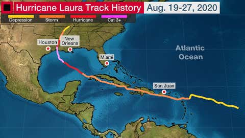
Hurricane Laura roared ashore in southwest Louisiana with a destructive storm surge, and spread damaging winds from east Texas and Louisiana into Arkansas.
(MORE: Latest News Impacts From Laura)
Laura made landfall near Cameron, Louisiana, at 1 a.m. CDT, August 27 as a strong Category 4 with 150 mph winds, southwest Louisiana's first Category 4 landfalling hurricane on record, according to NOAA's historical database.
Laura also tied the Last Island 1856 hurricane for strongest (by estimated wind speed) to landfall in Louisiana, according to Colorado State University tropical scientist Phil Klotzbach.
According to the National Hurricane Center, "Laura was the strongest hurricane to strike Louisiana since Hurricane Camille of 1969 (which produced category 5 conditions over the southeastern part of the state)."
Its central pressure at landfall was similar to Hurricane Rita in 2005, though Laura's winds were stronger.
The landfall was the culmination of a remarkable period of intensification after moving off the coast of western Cuba.
High Winds
Laura's eyewall produced extreme wind gusts in Louisiana and southeast Texas:
-Lake Charles, Louisiana: 133 mph
-Calcasieu Pass, Louisiana: 127 mph
-Cameron, Louisiana: 116 mph
-Sabine Pass, Texas: 89 mph
-Alexandria, Louisiana: 86 mph (video from Mike Seidel)
Storm chaser Mike Theiss measured a peak wind gust of 154 mph in the western eyewall of Laura near Holly Beach, Louisiana.
The winds knocked out power to more than 800,000 homes and businesses in southeast Texas, Louisiana, Arkansas and Mississippi, according to poweroutage.us.
Widespread wind damage was reported in Lake Charles, Louisiana, including numerous shattered windows in downtown skyscrapers, a TV tower collapsed, power poles toppled and roofs shredded.
(PHOTOS: Hurricane Laura's Destruction)
The extreme winds even destroyed the National Weather Service Doppler radar in Lake Charles, in similar fashion as what happened to another NWS Doppler radar in Puerto Rico during Hurricane Maria in 2017.
Trees and power lines were reported down "all over the city" in Shreveport, Louisiana, according to local law enforcement. Multiple downed trees and power lines also blocked roads throughout Caldwell Parish, Louisiana.
Other reports of significant wind damage came in from Monroe, Lafayette, Starks and Vinton, Louisiana, and Natchez, Mississippi. A church was damaged in Orange, Texas, near the Louisiana border.
Storm Surge
The highest storm surge inundation occurred in Cameron Parish, in far southwest Louisiana, where the worst inundation is estimated at around 18 feet. Water rose more than 20 miles inland across southwest Louisiana.
Satellite estimates and helicopter flyovers found areas near Cameron, Creole, Grand Chenier and Holly Beach suffered significant surge flooding.
In a Climate Central webinar on September 24, Perillo said he found a five-mile stretch near Grand Cheniere where 15-18 feet of water swept ashore during the peak of Laura's surge.
This is greater than the magnitude of Hurricane Rita's 15-foot peak storm surge from September 2005.
A National Weather Service-Lake Charles survey team found a high water mark of 17.2 feet above ground at Rutherford Beach, where the Mermentau River empties into the Gulf of Mexico.
While producing destructive winds in the hurricane's eyewall, Laura's center may have tracked just far enough east to spare the Lake Charles metro area a much worse fate than feared from surge flooding.
West to southwest winds to the south of Laura's center did pile water from Lake Charles into parts of downtown Lake Charles several hours after landfall early on August 27, in areas that were previously dry, according to storm chaser Chris Jackson. A peak storm surge of around 4.65 feet was measured by a gauge along Lake Charles downtown.
Storm surge of 3 to 5 feet was also measured around Vermilion Bay, along the south-central Louisiana coast. Some water pushed up the Vermilion River into parts of Lafayette, Louisiana. Feet of water was noted by local media in Delcambre, about halfway between Lafayette and Vermilion Bay.
Storm surge of about 2.4 feet was recorded in Port Arthur, Texas, and about 4 feet at Galveston. Laura's surge even reversed flow in the Neches River near Beaumont, Texas, for about 12 hours, according to the U.S. Geological Survey.
Rainfall Flooding
Overall, rainfall flooding wasn't quite as widespread as expected.
Flooding was reported across much of Natchitoches Parish, between Shreveport and Alexandria, Louisiana, on August 27. University underpass in Lafayette was impassable due to rising water.
Some streets and intersections were flooded in North Little Rock, Arkansas.
Tornadoes
Laura wasn't a prolific tornado producer, but it did spawn 16 tornadoes when it was inland over the Mid-South the evening and morning after its landfall.
An EF2 tornado tore through parts of Randolph County, Arkansas, near the Missouri border late on the night of August 27.
Another tornado heavily damaged a church east of Jonesboro, Arkansas.
The following morning, a tornado was sighted by emergency management just outside of Oxford, Mississippi.
Laura's Origin
Tropical Depression Thirteen formed in the Atlantic Ocean east of the Lesser Antilles on August 19 and strengthened into Tropical Storm Laura the following morning as it neared the Leeward Islands.
Laura was the earliest Atlantic 'L' named storm on record. The previous record was Luis on Aug. 29, 1995, according to Phil Klotzbach, tropical scientist at Colorado State University.
Laura brought heavy rainfall and gusty winds to the Leeward Islands and Puerto Rico. Southern parts of Puerto Rico picked up 2 to 6 inches of rainfall.
Winds gusted up to 75 mph at Salinas, along Puerto Rico's southern coast.
Portions of the Dominican Republic picked up nearly a foot of rain from Laura, which triggered serious flash flooding in some areas.
(MORE: Tropical Storm Laura Turned Deadly in the Dominican Republic, Haiti)
Sustained winds of 60 mph with a gust over 70 mph was measured in Guantanamo Bay, Cuba, on August 23.
Laura made landfall on the Pinar del Rio province in western Cuba around 8:00 p.m. August 24 with maximum sustained winds of about 65 mph.
While Laura's center remained well to the west of the Florida Keys, a wind gust of 69 mph was measured in Key West on August 24 as a line of showers on Laura's outer periphery moved through.
Laura then became the fourth hurricane of the 2020 Atlantic hurricane season on August 25, based on measurements taken by NOAA hurricane hunter aircraft.
National Hurricane Center forecasts were extraordinarily accurate regarding Laura's path.
Plymouth State meteorology associate professor Jason Cordeira noted the NHC forecast on August 23, 3 to 4 days before landfall, pinpointed the ultimate landfall of Laura's center within less than a mile.
The average NHC track error from 2015-2019 in a 72 to 96-hour forecast ranged between 111 and 153 statute miles.
The Weather Company’s primary journalistic mission is to report on breaking weather news, the environment and the importance of science to our lives. This story does not necessarily represent the position of our parent company, IBM.


