June 18, 2020
Drought Early Warning Update for the
North Central U.S.
|
|
Extreme Heat & Dry Conditions Forecasted to Persist: Potential Impacts in the Missouri River Basin & Midwest
|
|
This Drought Early Warning Update is issued in partnership between the National Oceanic and Atmospheric Administration (NOAA) and the U.S. Department of Agriculture (USDA) to communicate a potential area of concern for drought expansion and/or development within the North Central U.S. based on recent conditions and the upcoming forecast. NIDIS and its partners will issue future Drought Early Warning Updates as conditions evolve.
This covers the following states in the North Central U.S.: Colorado, Illinois, Indiana, Iowa, Kansas, Kentucky, Michigan, Minnesota, Missouri, Montana, Nebraska, North Dakota, Ohio, South Dakota, Wisconsin, and Wyoming.
A summary of the Drought Early Warning Update is provided below.
|
|
Key Points
- Drought conditions have been recently deteriorating over areas of the North Central U.S. (Colorado, Kansas, Minnesota, Montana, North Dakota, South Dakota, Wyoming). Abnormally dry conditions have recently expanded as well.
- A recent increase in atmospheric demand (i.e., crop water use) is starting to cause some stress on rangeland, grassland, and crops as soil moisture availability is decreasing.
- Forecasts show the possibility for rainfall in some areas over the next week. However, it is not likely to be widespread. In addition, there is a greater chance for above-normal temperatures across much of the north central U.S. through the end of June into early July. Therefore, for those that do receive rainfall, hotter temperatures will likely continue to worsen conditions in some areas.
|
|
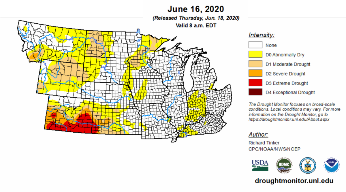
U.S. Drought Monitor Conditions
- Severe (D2) to extreme (D3) drought persists across much of Colorado and western Kansas.
- Moderate drought (D1) recently developed in portions of the Missouri River Basin and Midwest as well.
- Abnormally dry conditions (D0) also expanded this past week by around 10% in the Midwest and 8% in the Great Plains.
|
|
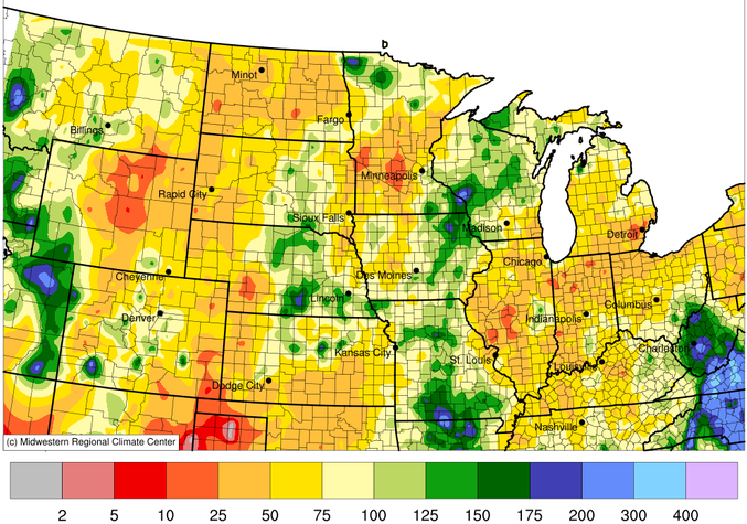
30-Day Percent of Normal Rainfall
May 20-June 18, 2020
Despite Tropical Depression Cristobal bringing significant rain to some areas in the Midwest, many areas in the North Central U.S. remain below normal for the past 30 days. Some areas only received 10-25% of normal for this time of year.
|
|
Midwestern Regional Climate Center climate:
|
|
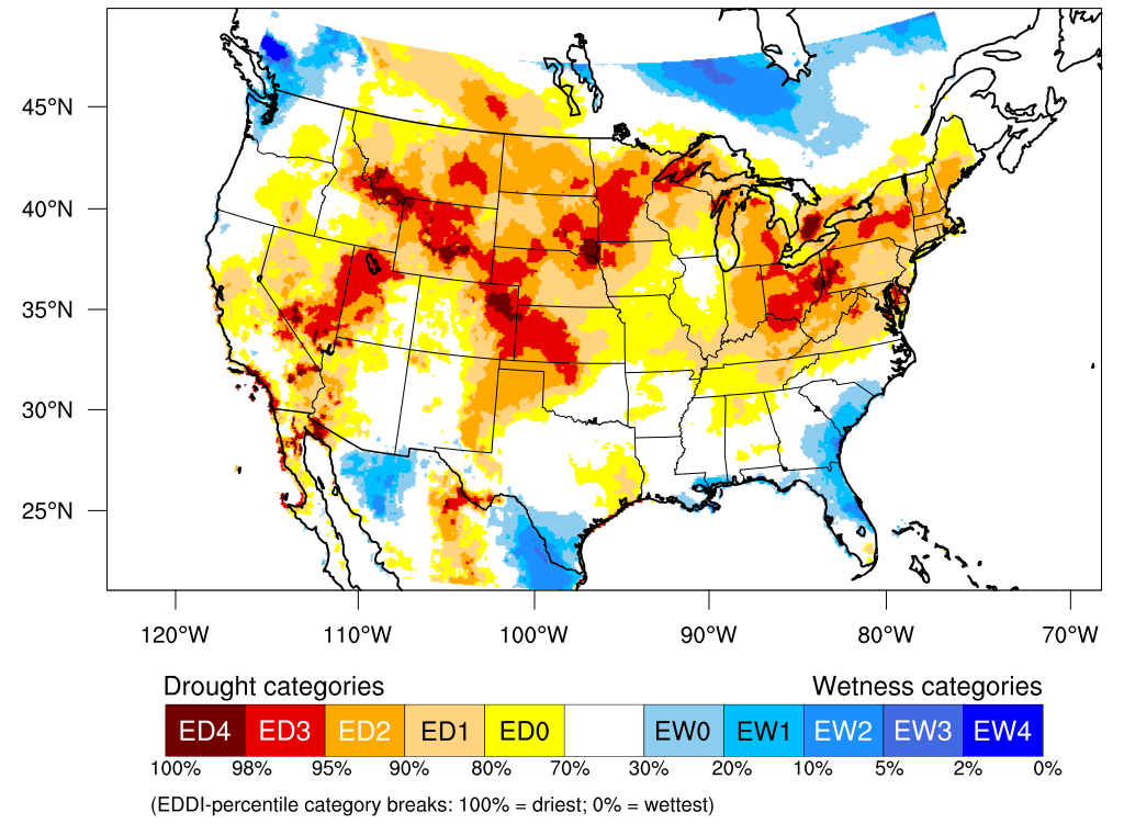
Evaporative Drought Demand Index (EDDI)
2-Week EDDI for June 12, 2020
Increased heat, wind, low humidity and ample sun recently have greatly increased atmospheric demand, which is reflected by this 2-week EDDI map.
|
|
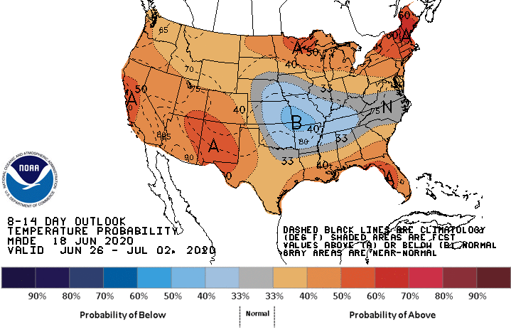
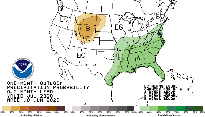
Temperature Outlook
There is a greater chance for above-normal temperatures across much of the North Central U.S. over the period of June 26-July 2.
|
|
Precipitation Outlook
Forecasts show the possibility for decent rainfall in some areas over the next week, however, precipitation is not typically widespread this time of year. For those areas that do receive rainfall, issues will likely still persist due to hot temperatures and therefore increased atmospheric demand.
Portions of the Missouri River Basin have greater chances for below-normal precipitation in July, while areas near the Ohio River Valley have greater chances for above-normal precipitation. Other areas have equal chances for above-, below-, or near-normal precipitation.
|
|
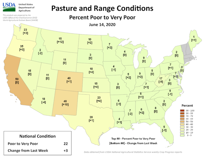
Agricultural Impacts
- A recent increase in atmospheric demand (i.e., crop water use) is starting to cause some stress on crops and rangeland as soil moisture deficits are increasing.
- Over the last couple of weeks, crop conditions have worsened according to USDA-NASS. The biggest impact will continue to be on rangeland and grassland. Crops are still early enough in growth stage to limit damage (except winter wheat).
- Heat continuing into early July would start to harm corn reaching reproductive stages (i.e., tasseling).
- Without timely and widespread precipitation, conditions will continue to deteriorate.
|
|
Prepared By:
Molly Woloszyn & Britt Parker
NOAA/National Integrated Drought Information System (NIDIS)
Dennis Todey
USDA Midwest Climate Hub
Doug Kluck
NOAA/National Centers for Environmental Information
Ray Wolf
NOAA/National Weather Service
Natalie Umphlett
High Plains Regional Climate Center
Mike Timlin
Midwestern Regional Climate Center
In partnership with the National Drought Mitigation Center (NDMC) and American Association of State Climatologists (AASC).
|
|
|
|
|
|
|